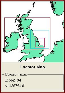
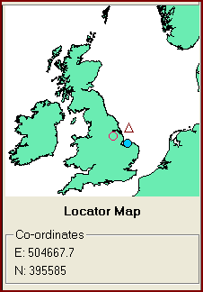
Locator Window
The Locator Window provides the context within which the current map extent lies. For instance, if you continue to zoom into a small part of the open ocean and pan around, you can quickly lose your bearings.
The Locator Window displays the current map extent as a red box. It also displays the current select area as a dark brown box and the extent of the currently select map layer as a blue box.
If the user zooms into the map to such an extent that the boxes within the Locator Window would not be visible, then symbols are displayed to indicate the centre of each component. A red circle is shown for the current map extent, a dark brown triangle for the select area and a solid blue circle for the extent of the current map layer.
The extent of the locator maps reflects the limits of the current map projection or the entire world if the projection state is 'Unprojected'.
| Browser Based Help. Published by chm2web software. |