Flood Ranger
Welcome to Flood Ranger, the game that tests your strategic skills. You will have to anticipate the effects of climate change, meet the demands of different world models, and balance the needs of people and the environment by building flood defences, houses, businesses and infrastructure. The world you are about to enter is made up of and upland national park, with peat bogs moors and grassland. In the central area there is a large city, situated on an extensive river network and estuary. Around this are towns and villages embedded in an agricultural and wooded landscape, and along the coast you'll find tourists resorts, a port and some very beautiful saltmarshes and conservation areas.
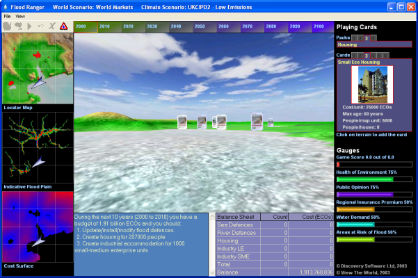
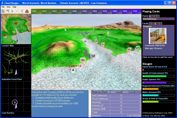
The game begins with two choices, the climate change and world futures scenarios. You will see the indicative flood plain, the map of flood risk, and the cost of building houses and flood defences in different areas shown on the left hand side, and the scoring bars for your performance on the right. At the bottom of the screen is the budget balance and instructions for each decade. Once you start, you will receive reports on how well you have done over the last decade and whether or not you have allowed people to become flooded, homeless or unemployed. Remember public opinion will determine whether or not you can keep your job. Good luck!
Flood Ranger Game
To start the game, click on the paint palette icon ![]() to
select the World
Scenario and then click on the cloud icon
to
select the World
Scenario and then click on the cloud icon ![]() to
select the Climate Change Scenario.
to
select the Climate Change Scenario.
Flood Ranger Window
The window includes the three-dimensional digital terrain map over which Flood Ranger can move (see overflight instructions). The virtual landscape in Flood Ranger is described several overlays. Under the View menu, you can select which of these overlays you wish to see displayed across the terrain.
Managing Flood Risk
The aim of Flood Ranger is to manage the risk of flooding in response to climate change and the demands of different world scenarios. To help the Flood Ranger there are two types of defences: sea defences and river defences.
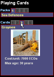
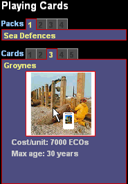
To add a defence to the virtual landscape you must select a card from those available in the upper-right corner of the game window. Move your cursor over the 'pack' heading to select cards from four different groups: Sea Defences, River Defences, Housing, and Industry. Similarly, once you have chosen a pack, move your cursor over the numbers available to highlight the card you require. To add it into the game click on the picture, which is then highlighted with a red border.
You must then position the card on the terrain. A cost surface
is shown in the bottom-left corner of the window. This helps you position your
card. As you move your cursor across the landscape you will notice a target
marker drawn upon the cost surface corresponding to the cursor's position within
the overall map of the area. The colour of the cost surface indicates the relative
cost of building at any point in the map. Blue is relatively cheap while red
is the most expensive. Black indicates that you cannot build at that location.
Also as you move your cursor around the terrain the cursor displays (in text
next to the arrow) the relative cost from the cost surface. A value of 1.0
is the cheapest. The maximum may be anything from 3 to 20 depending on the
type of card selected. Once you have selected an area to add the card left-click
on the terrain at that location. You can undo the card placement using the
undo icon ![]() on the toolbar or delete
it later (but only during the current decade of the game) using the delete
icon
on the toolbar or delete
it later (but only during the current decade of the game) using the delete
icon ![]() .
.
When not adding a card the image in the lower left corner displays the current flood risk given the defences that you have in place. If you have defences in place for a stretch of river or coastline then the pixels within that stretch will not be coloured and will appear black. If your level of defences have degraded or have been purchased at < 1:100 for rivers or < 1:200 for coastal stretches then pixels to the outermost reaches of the flood plains will be coloured, indicating that floods will reach these areas if a future flood event is large enough to breach the defences currently in place (obviously all pixels within the floodplain extent of these areas will also be flooded.
The idea of the game is to minimise the risk of flooding, so when playing the game you need to reduce the risk shown on this map particularly in or near urban areas. An important point to note is that any particular point in the landscape may be flooded from more than one source location. For example, areas near to the confluence of two rivers may be flooded from the direction of either river and in order to defend such locations you will need to defend flooding events from both rivers. The major city in the centre of the landscape is a good example of this and the flood risk map will not turn black unless all sources of possible flooding are defended against.
Each river and coast is divided into management sections (or
stretches). These can be seen on the terrain by clicking on the warning icon
![]() on the toolbar.
on the toolbar.
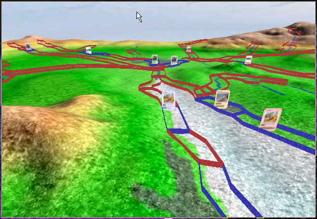
The level of defences are shown as 'walls' on the terrain delimiting the each management area. If a wall is coloured red then it is not currently defended, conversely if it is coloured blue then defences are in place.
Meeting the demands of the world future scenarios with Flood Ranger
At the start of each decade, Flood Ranger issues a set
of instructions regarding development and construction of flood defences
in order to meet the demands
of the selected world scenario. These are based on the projected increases
in population and family unit size, changes in industry and enterprises and
changes in visitor numbers, There are two key elements, depicted by sets
of playing cards, to be manipulated: housing and industry. If insufficient
houses or industrial developments of the right kind are built then the number
of homeless and unemployed will rise and as a consequence public opinion
will fall.
| Browser-based HTML Help. Published by chm2web software. |